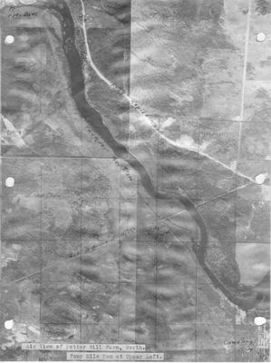
Aerial View of Potter Hill Farm and Four Mile Dam
Description
- Media Type
- Image
- Item Type
- Aerial photographs
- Description
- Aerial view from Potter Hill Farm (center lower left) to Four Mile Dam (upper left) along the Thunder Bay River and Long Rapids Road, Alpena County, Michigan
- Date of Original
- c1950s
- Dimensions
-
Width: 4899 px
Height: 6555 px
- Image Dimensions
-
Image Width: 4899px
Image Height: 6555px
- Subject(s)
- Corporate Name(s)
- Potter Hill Farm ; Potter Farm
- Collection
- Fred Trelfa Collection
- Language of Item
- English
- Geographic Coverage
-
-
Four Mile Dam:
Michigan, United States
Latitude: 45.0936816148865 Longitude: -83.5021011962891 -
Potter Hll Farm:
Michigan, United States
Latitude: 45.0742130703342 Longitude: -83.4806435241699
-
Four Mile Dam:
- Copyright Statement
- Copyright status unknown. Responsibility for determining the copyright status and any use rests exclusively with the user.
- Recommended Citation
- Fred Trelfa Collection, Alpena County George N. Fletcher Public Library
- Contact
- Alpena County George N. Fletcher Public LibraryEmail:specialcollections@alpenalibrary.org
Website:
Agency street/mail address:211 N. First Ave.
Alpena, Michigan 49707
USA
(989)356-6188


