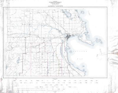
Michigan Department of Conservation Land Economic Survey - Base Map of Alpena County (1924)
Description
- Media Type
- Image
- Item Type
- Maps
- Description
- This map details a base map of Alpena County in Michigan as part of the Land Economic Survey project in 1924 by the Michigan Department of Conservation. Below conventional signs culture, there are handwritten notes detailing the oil aggregate project as proposed the Alpena Co Rd. Commission and Michigan State Highway. The original map was published in 1924, handwritten notes were added from an unknown date. Shown on this map are county schools, churches, logging camps, railroads, and telephone lines.
- Date of Publication
- 1924
- Dimensions
-
Width: 24919 px
Height: 19771 px
- Subject(s)
- Personal Name(s)
- Hoen, August
- Corporate Name(s)
- Michigan Department of Conservation ; A. Hoen & Co Lithograph ; Hoen & Company
- Local identifier
- M 2-12
- Language of Item
- English
- Geographic Coverage
-
-
Michigan, United States
Latitude: 45.06168 Longitude: -83.43275
-
- Copyright Statement
- Public domain: Copyright has expired according to United States law. No restrictions on use.
- Copyright Date
- 1924
- Location of Original
- Map Storage Sh: 2 Item: 12
- Contact
- Alpena County George N. Fletcher Public LibraryEmail:specialcollections@alpenalibrary.org
Website:
Agency street/mail address:211 N. First Ave.
Alpena, Michigan 49707
USA
(989)356-6188


