
Sanborn Fire Insurance Map from Alpena, Michigan 1924
Description
- Creators
- Sanborn Map Company
- Alpena Power Company
- Media Type
- Publication
- Item Type
- Maps
- Description
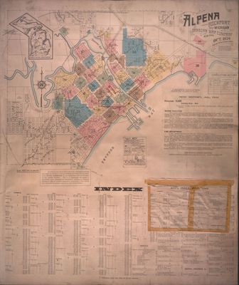
- Sanborn Map Company made this detailed map in 1924, which was later amended in 1938 and 1944. Such maps were created for fire insurance companies to assess liability in urbanized areas all over the United States. This map's scale is 100 ft. for every inch.
Sheet one includes the index for every sheet, a key to the colors, and basic community information. - Notes
- Colored pen marks were made on each page by Alpena Power Company staff to notate the power lines installed.
- Publisher
- Sanborn Map Company
- Place of Publication
- New York
- Date of Original
- October 1924
- Language of Item
- English
- Geographic Coverage
-
-
Michigan, United States
Latitude: 45.06168 Longitude: -83.43275
-
- Copyright Statement
- Copyright status unknown. Responsibility for determining the copyright status and any use rests exclusively with the user.
- Terms of Use
- Open to research. Contact the George R. and Edith Angell Cook Special Collections Department at specialcollections@alpenalibrary.org for any other uses.
- Contact
- Alpena County George N. Fletcher Public LibraryEmail:specialcollections@alpenalibrary.org
Website:
Agency street/mail address:211 N. First Ave.
Alpena, Michigan 49707
USA
(989)356-6188
Request image
Comment on this item
Create electronic postcard

Groups of Related Records
Other Web sites/External links
