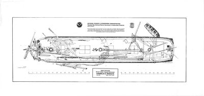
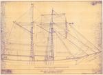
Archaeological Site Plan of Schooner CORNELIA B. WINDIATE
Description
- Creator
- C. Patrick Labadie, Draftsman
- Media Type
- Image
- Ship
- Item Type
- Plans
- Description
- An archaeological site map of the wrecked Schooner Cornelia B. Windiate drawn by C. Patrick Labadie in February 2004 based on field work conducted by NOAA-TBNMS in July 2003.
- Place of Publication
- Alpena, MI
- Date of Publication
- 2004
- Dimensions
-
Width: 36 in
Height: 25 in
- Map Scale
- 1 in = 4 ft
- Subject(s)
- Personal Name(s)
- Labadie, C. Patrick
- Corporate Name(s)
- National Oceanographic and Atmospheric Administration
- Local identifier
- OS 2-25
- Collection
- C. Patrick Labadie Collection
- Language of Item
- English
- Donor
- C. Patrick Labadie
- Copyright Statement
- Copyright status unknown. Responsibility for determining the copyright status and any use rests exclusively with the user.
- Copyright Date
- 2004
- Copyright Holder
- NOAA & C Patrick Labadie
- Copyright Holder Contact Information
- 500 W Fletcher St, Alpena, MI 49707
(989) 356-8805 - Recommended Citation
- C. Patrick Labadie Collection, Thunder Bay National Marine Sanctuary. Alpena, MI
- Location of Original
- Oversized Shelving: Shelf 2 Item 25
- Contact
- Alpena County George N. Fletcher Public LibraryEmail:specialcollections@alpenalibrary.org
Website:
Agency street/mail address:211 N. First Ave.
Alpena, Michigan 49707
USA
(989)356-6188


